
Payload Options
Our integrated sensing solutions include thermal imaging, visible-light imaging, video analytics, measurement, and diagnostic, advanced threat detection systems as well as state of the art collision avoidance.
The products on this page are simply a just of some of the sensors we have integrated with our aircraft system previously. If you have existing sensors, or would like integrate anything not displayed below, we can ensure it will work with all components of our aircraft systems. The shadow quad is designed for payload modularity.

Velodyne the Puck Hi-Res
Higher resolution option in the Puck family
Proven, Class 1 eye-safe 905 nm technology
Best-in-class accuracy and calibrated intensity
Best-in-class power & temperature range
Sensor-to-sensor interference mitigation feature
Versatile, with attractive volume pricing

HDL-32E High Resolution Real-Time 3D Lidar Senso
Ruggedly built with an unrivaled field of view
Dual Returns, Low Power Consumption
± 2 cm accuracy
1kg (plus 0.3kg for cabeling)
32 Channels
80m-100m Range
Up to ~1.39 Million Points per Second
360° Horizontal FOV
+10° to -30° Vertical FOV

Trilliam HD 25
Machined Magnesium Housing - robust and environmentally sealed
Onboard GPS/INS - accurate gimbal and target location
MISB Compliant Video - h.264 video and KLV metadata
Onboard Video Processing - electronic image stabilization and scene tracking
Video and Control Over Ethernet - single 10/100 connection
Direct Drive Motors - best in class stability
Non-ITAR - simple export options

FLIR DUO PRO R
VISUAL AND THERMAL
Uses: Inspection, ISR
4000 x 3000 visible sensor
640 x 512, 30Hz thermal imaging
Gremsy T1 Gimbal
Radiometrics/temperature measurement


ROUTESCENE LIDARPOD
LIDAR
Uses: Surveying, Mapping
Complete Turnkey Mapping System: Visualization, quality assurance, and post processing software
Based on Velodyne HDL-32 sensor
700,000 points per second
Dual returns
Infra-red 905 nm wavelength

The RIEGL miniVUX-1UAV
360° field of view
Robust aluminium housing, 1.55 kg / 3.4 lbs
signal digitization and online waveform processing
Multiple target capability – up to 5
Scan speed up to 100 scans/sec
Measurement rate 100,000 measurements/sec
measures snowy and icy terrain

PHOENIX LIDAR AL3-32
LIDAR
Uses: Surveying, Mapping
Visualization and processing software
Based on Velodyne HDL-32 sensor

MICASENSE REDEDGE
MULTISPECTRAL
Uses: Agricultural
Five narrow bands 12 bit sensors
8cm/pixel at 400ft

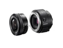
SONY A6500
VISUAL
Uses: ISR, Inspection, Mapping
APS-C Exmor sensor
24.2 MP
5-Axis in-body stabilization
11 frames per second continuous shooting
4K movie with 2.4X oversampling

SLANTRANGE 3P
MULTISPECTRAL
Uses: Agricultural
No network required.
Complete software suite for stitching + analyzing photos.
4 Spectral Channels. 4.8 cm / pixel at 400 ft AGL
4X area coverage, requiring minimal overlap
SONY UMC-R10C
VISUAL
Uses: Mapping
APS-C size sensor
20 MP still image
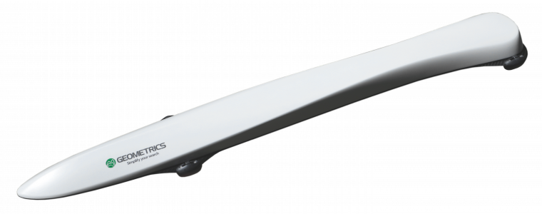
GEOMETRICS MAGARROW
MAGNETOMETRY
Uses: Unexploded Ordinance / Wellhead Detection, Resource exploration
1 nanotesla sensitivity
No data drop outs
Works in all orientations
Integrated IMU and GPS

INOVA DRONE EAGLE EYE 640
3-AXIS STABILIZED DUAL EOIR PAYLOAD WITH LASER POINTER
SPECS:
3-
Axis brushless stabilization:
Sony EV7500 30X optical zoom 1080p; HD camera;
FLIR 640X512 with 0-8X zoom;
20 mW green laser pointer;
Gimbal stabilization controller with auto tune;
Multi mode vibration isolation;
120 degree yaw rotation;
Universal payload mounting plate/ adapter system;
Auto defog and low light night mode;
Digital EO and IR image stabilization;
H.264 Ethernet HD video streaming output with 128/256 bit encryption;
PPM input for RC of modes;
12 V system input power;
On board SD card storage;
Approximate dimensions: 155 mm H x 138 mm W x 160 mm L

10X 3 Axis HD Camera Payload System
Features HD 1080p 10x optical zoom camera; m
High precision driving algorithm, independent IMU to control PTZ posture, attitude control accuracy reaches 0.02 degrees, the integrated precision servo drive module;
Point angle is 420 degrees, support 3-6S wide voltage input:
Micro-SD card slot is overhead to avoid the rain influence;
HDMI1.4 HD output port;
Support SBUS decoding module upgrade port, using the Micro- USB link to connect the computer to upgrade parameters; The F2.0 uses 1/3 colour CMOS4 image sensor which supports approx.4 million effective pixels (2688 x 1520)